
On Sunday 1 November 2026, a Learjet 60 crashed in a residential and commercial area of Palm Beach County, Florida, near Greenacres and West Palm Beach. All nine people on board were killed. According to the authorities there were no deaths on the ground, though one person in a vehicle near the impact point was reported to have a leg injury.
Our thoughts are with the families and friends of everyone on board. This post sets out only what the NTSB has said in public so far. The cause has not been determined, and the NTSB itself has said it will not speculate about it. After the facts, we look at what the FAA's own guidance says about the kind of weather the crew described, because that guidance is useful to pilots of any aircraft.
What the NTSB has confirmed
At a press briefing in West Palm Beach on Monday 2 November, NTSB Member Tom Chapman and the investigator in charge gave this account, in local time:
- The flight: a Learjet 60, registration N722BD, operated by Aurora Aviation (doing business as Upper Jets) as a Part 135 charter flight. Part 135 is the US rule set for commercial charter and air-taxi operations. It left Austin-Bergstrom International Airport, Texas, at about 10:37 a.m., bound for North Eleuthera in the Bahamas, with two crew and seven passengers.
- 12:47 p.m.: the crew told air traffic control they were encountering light clear ice, which they described as manageable, and moderate turbulence. They told Miami Center they were at 35,000 ft with altitude deviations of about 700 ft. They reported an outside air temperature of −47 °C.
- Next: the crew asked to climb to 37,000 ft, and air traffic control approved it. Less than 30 seconds later, a transmission from the aircraft announced a descent, followed by a mayday call.
- About 12:48 p.m.: the aircraft transmitted "we are in an overspeed condition descending", and the rest of the call was unintelligible. Later calls said the aircraft was descending rapidly and gave an altitude.
- About 12:51 p.m.: the aircraft crashed.
Chapman said the NTSB has "some evidence" that the aircraft broke up before impact, and that the investigation still has to determine this. Debris was spread over an area of roughly half a mile by four-tenths of a mile. The main wreckage lies in a crater in a roadway, and recovering it is the biggest practical obstacle. Aviation Week reported that the aircraft was 22 years old, serial number 271.
The Weather at the Time of the Crash
The accident happened at about 12:51 p.m. Eastern Standard Time on Sunday 1 November 2026 (about 17:51 UTC). Florida had already switched to standard time that morning, so local time was UTC−5. At the NTSB briefing the next day, Member Tom Chapman said weather conditions are a major focus of the investigation, that there was heavy rain and scattered thunderstorms in the area at the time of the crash, and that investigators still have to determine what the weather was like at altitude. The NTSB has not confirmed whether the aircraft flew through an active thunderstorm.
What the crew reported to Miami Center around 12:47 p.m. Eastern (about 17:47 UTC), according to the same briefing, was light clear ice they described as manageable, moderate turbulence with altitude deviations of about 700 ft while at 35,000 ft, an outside air temperature of −47 °C (−53 °F), then precipitation and a request to climb to 37,000 ft.
Surface observations near the crash
Palm Beach International (KPBI) did not return usable METARs in the public archive for that afternoon. The nearest reporting airport with continuous observations is Palm Beach County Park (Lantana, KLNA), about 3 nm from the crash site. From the Iowa Environmental Mesonet ASOS archive:
KLNA 011735Z AUTO 12007G19KT 3SM VCTS SCT023 BKN029 OVC037 26/22 A3008 RMK AO2 LTG DSNT W THRU N T02620215
Decoded: 17:35 UTC (12:35 p.m. Eastern), about 16 minutes before the crash — wind 120° at 7 kt, gusting 19 kt; visibility 3 statute miles; thunderstorms in the vicinity (VCTS); scattered clouds at 2,300 ft, broken at 2,900 ft, overcast at 3,700 ft; temperature 26 °C, dew point 22 °C; altimeter 30.08 inHg; lightning distant west through north.
KLNA 011755Z AUTO 09012G19KT 7SM VCTS OVC021 27/22 A3007 RMK AO2 LTG DSNT ALQDS T02660218 10277 20260
Decoded: 17:55 UTC (12:55 p.m. Eastern), a few minutes after the crash — wind 090° at 12 kt, gusting 19 kt; visibility 7 miles; thunderstorms still in the vicinity; overcast at 2,100 ft; temperature 27 °C, dew point 22 °C; lightning distant in all quadrants.
Boca Raton (KBCT), farther south, reported rain and distant lightning around the same time:
KBCT 011753Z 10015G20KT 7SM RA BKN020 BKN065 26/24 A3007 RMK LTG DSNT ALQDS
Those are surface observations. They describe the stormy weather on the ground; they do not by themselves describe the air at 35,000 ft, where the crew's radio calls are the main public firsthand report so far.
Convective SIGMETs in force
At the time of the accident, an FAA Convective SIGMET covered a large part of the Florida peninsula and adjacent waters. From the IEM AFOS archive, Convective SIGMET 45E, issued at 16:55 UTC and valid until 18:55 UTC, read:
CONVECTIVE SIGMET 45E
VALID UNTIL 1855Z
FL AND CSTL WTRS
FROM 70ESE OMN-70E MIA-50E EYW-20WNW PIE-70ESE OMN
AREA TS MOV LTL. TOPS ABV FL450.
In plain language: an area of thunderstorms over Florida and coastal waters, moving little, with tops above flight level 450 (45,000 ft). The polygon runs from east of Ormond Beach to east of Miami, east of Key West and west-northwest of St. Petersburg — a footprint that includes the Palm Beach County corridor. At 17:55 UTC, minutes after the crash, Convective SIGMET 48E was issued for a similar area (from northeast of Treasure Coast / TRV through east of Miami, east of Key West, Fort Myers and Orlando), again with thunderstorm tops above FL450.
Freezing level and the altitude of the upset
The Miami sounding (KMFL) at 12:00 UTC on 1 November, from the IEM RAOB archive, put the 0 °C level near about 15,700 ft MSL. At about 35,000 ft the same sounding showed roughly −43 °C, close to the −47 °C the crew reported. Public ADS-B data in this post show the rapid descent beginning near 35,000 ft — well above that freezing level — and the last reported altitude change near 8,750 ft. Crossing the freezing level during a high-speed descent is a fact of the profile; what that means for the accident is for the NTSB to determine.
Separately, the National Weather Service in Miami had a Flood Watch in effect through Monday afternoon for metro Palm Beach County (including Greenacres) and much of South Florida, for flooding from excessive rainfall.
What the Flight Track Shows
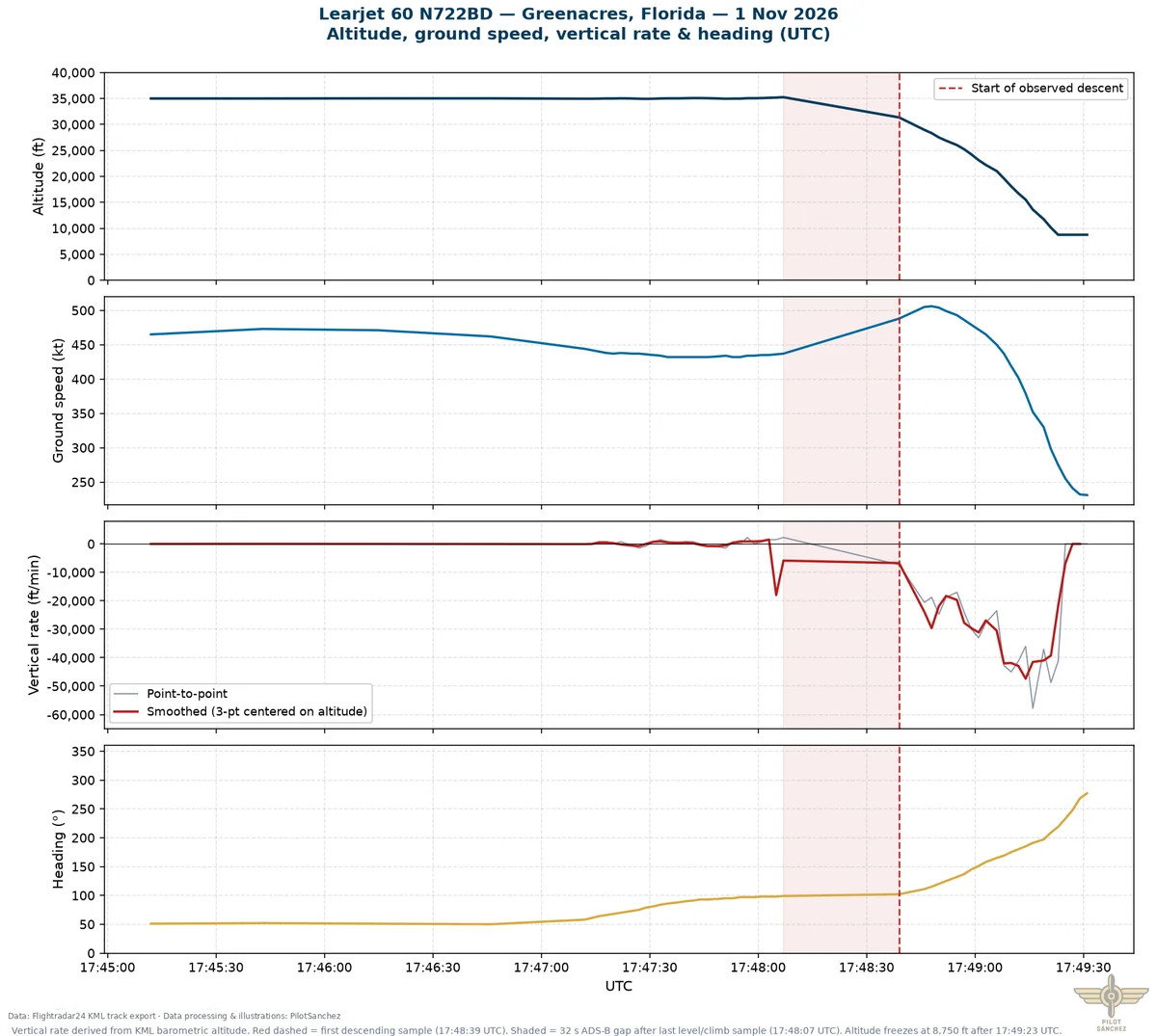
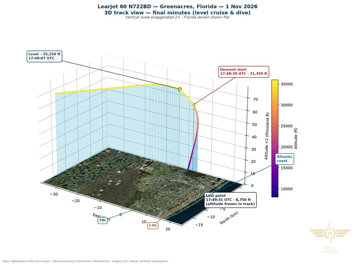
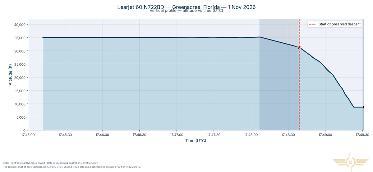
Public ADS-B data for N722BD lets us plot the final minutes in UTC (Florida was on Eastern Standard Time, UTC−5, so 17:48 UTC was about 12:48 p.m. local). These figures are approximate, based on public ADS-B data, not official NTSB data: sampling is about every 2 s in the accident window, there is a 32 s gap just as the descent begins, and the vertical rate is derived from barometric altitude in the track.
Earlier in the flight the aircraft reached a maximum altitude of 41,025 ft at 16:02:39 UTC. In the minutes before the accident it was level at 35,250 ft at 17:48:07 UTC — the last level point before a 32 s data gap. The first descending sample is at 31,350 ft at 17:48:39 UTC, so the descent began inside that gap. The last altitude that still changes is 8,750 ft at 17:49:23 UTC; the last point is at 17:49:31 UTC with altitude frozen. The observed fall lasts 44 s from the first descending sample to the last changing altitude.
Peak point-to-point descent rate is about −57,750 ft/min between two samples 2 s apart; smoothed over three points it is about −47,000 ft/min. The average over the observed descent is about −30,800 ft/min. None of this explains why the aircraft came down — only how steep the recorded path was.
What the investigation is looking at
The NTSB said weather conditions are a major focus, in particular what the weather was like at 35,000 ft. It also said it is looking at what the crew and air traffic control knew and when, and whether the actions taken were appropriate. Maintenance records show a cockpit voice recorder was fitted to the aircraft, and investigators are working out whether it was installed on this flight and whether it can be recovered. The NTSB will not determine a probable cause at the scene, which will take several days to document. The NTSB normally publishes a preliminary report within about a month, and we will add an update to this post when it does.
Weather guidance that applies to every pilot
A Learjet 60 cruising at FL350 is a long way from a Cessna 172, and nothing published so far says that any of the following played a part in this accident. But icing, turbulence and convective weather are exactly what the crew described, and the FAA has written clear guidance on all three.
Thunderstorms and turbulence
The FAA's Aeronautical Information Manual (AIM), section 7-1-27, is direct:
- Avoid by at least 20 miles any thunderstorm identified as severe or giving an intense radar echo, especially under the anvil of a large cumulonimbus.
- Regard as extremely hazardous any thunderstorm with tops of 35,000 ft or higher.
- Don't use data-linked NEXRAD radar imagery as your only way to pick a path through storms. It shows where the weather was, and may be 15 to 20 minutes old.
- If you can't avoid turbulence, fly the turbulence penetration airspeed in your aircraft manual, hold a constant attitude, let altitude and airspeed vary, and with an autopilot, disengage altitude hold and speed hold.
Icing
The FAA's advisory circular AC 91-74B, Pilot Guide: Flight in Icing Conditions, makes several points that matter at any altitude:
- If your aircraft isn't certificated for flight in icing conditions, plan the flight so you avoid icing. If you meet it inadvertently, exit as quickly as you can and, if needed, declare an emergency. The AC cites a study of US icing accidents in which pilots often expected a blanket clearance from ATC without declaring one, which it says proved not only false but, in many cases, fatal.
- A thin layer of ice on critical surfaces, built up in a matter of minutes, can have dramatic effects on stall speed, stability and control.
- Ice protection fitted to aircraft not certificated for icing is for emergency use only. The AC warns that performance is unknown, that stall warning most likely won't activate before the stall, and that controls may jam.
- The AC also describes a threat for turbine engines: ice crystals near convective weather, which can occur at altitudes up to 42,000 ft in temperatures colder than −45 °C, don't build up on the airframe and may not show on airborne radar. We mention it only because it is part of the FAA's guidance on high-altitude icing, not because it has been linked to this accident.
For your own flights
- Check the forecast and actual weather before you go, and again in flight. Our guide to reading METARs and TAFs and our VFR preflight checklist are a good start, and the Briefing tool puts the weather for your route in one place.
- Know your aircraft's turbulence penetration speed and its icing approval before you need them.
- Decide in advance where you will divert, and use that decision as soon as the weather stops matching the forecast.
- Remember that carburettor icing doesn't need cold weather either: see carb icing in warm weather.
The NTSB's investigation will take many months. When it reports, we will return to it. For now the best use of this accident is to revisit the weather decisions in our own flying.
Cover: Learjet 60 N722BD approaching Sint Maarten, 4 February 2024. Photo: Mike Illien, Wikimedia Commons, CC BY-SA 4.0.
Sources
- NTSB, Media Briefing 1, Palm Beach County, FL Learjet 60 airplane crash, 2 November 2026 (video)
- Aviation Week, "Icing, Turbulence Possible Factors In Fatal Learjet 60 Crash", 2 November 2026
- PilotinQ, "NTSB has evidence Learjet 60 began to break up before impact in Florida", 2 November 2026
- UPI, "Texas couple, children, others identified as passengers in Learjet crash", 2 November 2026
- FAA, Aeronautical Information Manual, 7-1-27 Thunderstorm Flying
- FAA, AC 91-74B, Pilot Guide: Flight in Icing Conditions (PDF)
- ADS-B data obtained via Flightradar24 KML export
- Iowa Environmental Mesonet, ASOS/METAR archive (KLNA, KBCT), 1 November 2026
- Iowa Environmental Mesonet, AFOS archive: Convective SIGMET 45E and 48E (SIGE), 1 November 2026
- Iowa Environmental Mesonet, KMFL radiosonde (RAOB), 12:00 UTC 1 November 2026
- National Weather Service Miami, Flood Watch (FFAMFL), 1 November 2026
