On 28 January 1984 at 12:00 GMT, two weather stations less than a hundred kilometres apart told completely different stories. Tarifa reported an east wind of 93 km/h, 85% humidity and five oktas of cloud. Cádiz, up the Atlantic coast, had an east-south-easterly of 38 km/h, a much drier 63% and two oktas.
Same day, same weather system, same wind. That's the Levante: a wind that can be a nuisance in one place and a serious problem a short flight away. If you fly anywhere between Huelva and Almería, it pays to understand it, and its opposite number, the Poniente.
A funnel between two continents
At its narrowest the Strait of Gibraltar is about 14 km wide, with the Betic ranges on the Spanish side and the Rif on the Moroccan side. Any wind that blows along the Strait gets squeezed between those mountains and speeds up. Meteorologists describe it as a Venturi or funnel effect.
The two dominant winds are simple to define:
Levante: easterly, roughly from ENE to ESE (070° to 110°).
Poniente: westerly, roughly from WSW to WNW (García de Pedraza gives the sector from 250° to 330°).
Which one you get depends on where the pressure is. With high pressure over the western Mediterranean, the Balearics or the Bay of Biscay and lower pressure towards the Gulf of Cádiz, Morocco or the Canaries, the air flows from east to west through the Strait: Levante. Reverse the pattern, typically when Atlantic lows track across southern Iberia, and you get Poniente.
A practical tip from an old AEMET description that still holds: a slight drop in the barometer and a rise in temperature in the Gulf of Cádiz are a sign the Levante is setting in, and a marked rise in pressure at Cádiz suggests it is about to stop.
The Levante: persistent, humid and murky
The classic study by Lorenzo García de Pedraza, published by Spain's national weather service, gives a good picture of the Levante in the Strait:
It blows on about 165 days a year on average, most often from May to August (around 16 days a month) and least often from November to February (around 10).
It is persistent. Episodes of 7 to 10 days in a row are possible.
Average speeds of around 25 knots, with gusts that can exceed 90 to 110 km/h.
It brings warm, humid Mediterranean air, with poor visibility, haze and occasionally Saharan dust.
It also has variants that matter for planning. With a more ENE direction, the Spanish coast tends to stay clear and the cloud piles up on the African side. With a more ESE direction, the opposite happens: cloud banks up against the coastal mountains of the Costa del Sol, sometimes with drizzle. Meanwhile, on the lee side, air coming down off the mountains is dried and warmed by the foehn effect. Around Cádiz, a south-easterly that has dropped its moisture over the mountains of the Strait arrives hot and dry. Locals have a name for it, matacabras ("goat killer"), and the poet José María Pemán said it "untunes nerves and guitars".
The Rock's flag
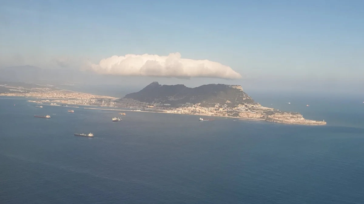
The most famous sign of the Levante is the cloud that sits on top of the Rock of Gibraltar. Moist easterly air hits the Rock, is forced to rise quickly, condenses into a lenticular stratocumulus cap and streams away downwind. It has even been included, as the "Levanter cloud", in the World Meteorological Organization's International Cloud Atlas.
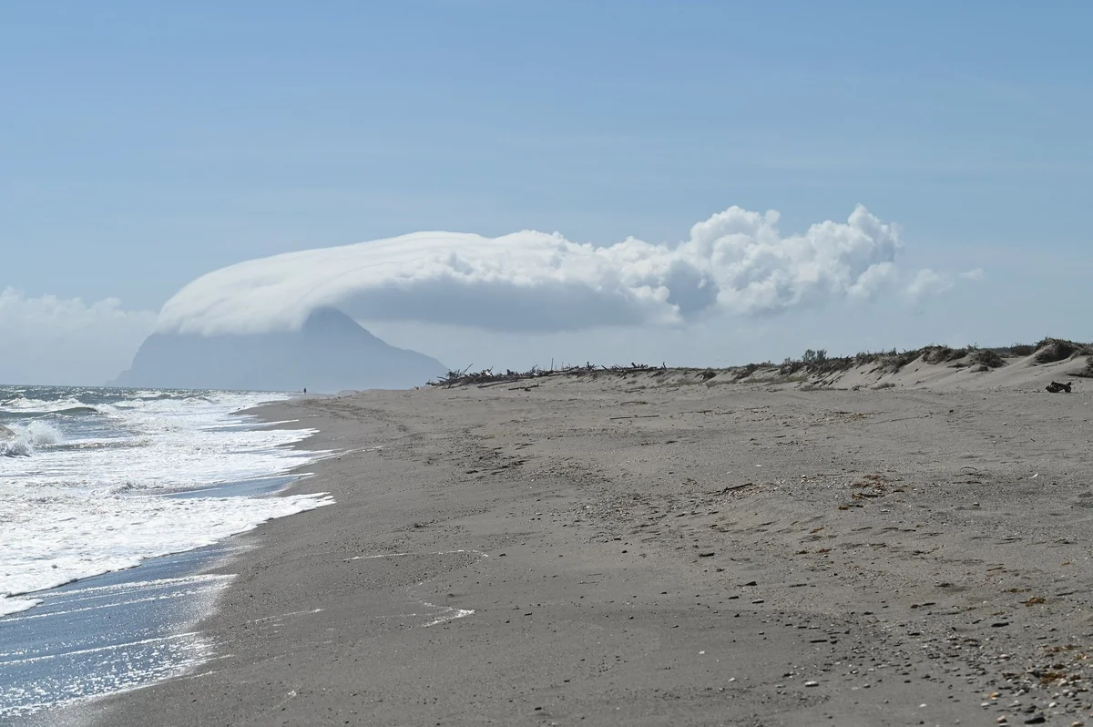
The same phenomenon from sea level, seen from the beach south of Sotogrande. Locals say "si el Peñón tiene montera, levantera": if the Rock wears a cap, the Levante is blowing.
As a pilot, you should read that cloud as more than a postcard. According to AEMET, the same process sets up a mountain wave downwind of the Rock, with rotors (horizontal eddies) in the lower levels below the lenticular cloud. Rotors mean low-level turbulence.
Gibraltar's own AIP makes the point bluntly. When the wind is between 110° and 250° at more than 15 knots, significant turbulence should be expected during the approach and the final stages of flight in the lee of the Rock, and it "can make landing dangerous or impossible". The published table puts the threshold at 27 kt with a wind from 110° magnetic, falling to 22 kt at 120°, 19 kt at 130°, 17 kt at 140°, 15 kt at 150° and 14 kt at 160°. The more southerly the wind, the less of it you need. The AIP also warns that south-westerly winds above 25 kt can produce waterspouts on the approach to runway 27.
Gibraltar is operated by the UK Ministry of Defence and needs at least four hours' prior permission, so most GA pilots won't land there. But the physics is the same for any ridge, headland or sierra along this coast with a strong wind blowing over it.
The Poniente: short, gusty and clear
The Poniente is a very different animal. According to García de Pedraza:
It blows on about 60 days a year, mostly from October to April.
It is strong and gusty but short-lived, often lasting from 6 to 14 hours, though deep lows over the north of Spain can keep a westerly going for 36 to 48 hours.
It arrives with Atlantic lows and their fronts, so expect showers and heavy rain, especially in the Málaga–Motril area.
Behind the fronts, visibility is usually very good and the air is fresh.
Put simply, the Levante tends to give you poor visibility and steady wind for days; the Poniente gives you great visibility and gusty, changeable wind for hours, often with frontal weather on either side.
What it looks like at Málaga: Terral and a south-east Levante
If you fly around the Costa del Sol, AEMET's aerodrome weather guide for Málaga-Costa del Sol (LEMG) is one of the most useful documents you can read. A few points from it:
Because of the Guadalhorce valley, which runs north-west to south-east, the two most typical wind regimes at the airport are north-westerly (the terral) and south-easterly (the Levante, channelled up the valley).
The terral is a northerly wind that warms as it descends on the lee side of the mountains around Málaga and accelerates down the valley, bringing high temperatures and strong gusts. AEMET identifies it as one of the factors behind wind shear and turbulence on approach. In one episode, on 27 December 2017, the strong gusts led to reports of two go-arounds due to wind shear.
In the 2005–2019 data, the north-west (around 300°) is the most frequent wind direction at the airport, about 30% of the total, followed by the south-east (around 135°). The strongest winds come from between west and north-west, and the north-westerly gusts are by far the most frequent.
In AEMET's example of a Levante day in May, the synoptic easterly and the afternoon sea breeze reinforced each other, with a southerly component and gusts above 15 kt for most of the day.
The same guide describes two kinds of fog worth knowing: sea fog over the Alborán Sea in summer, typically forming after sunset on clear days with light winds and dispersing around midday; and radiation fog in the Guadalhorce valley in autumn and winter, which can drift down towards the airport and usually affects the runway thresholds furthest from the coast.
Practical rules of thumb
Look at the pressure chart first. High over the western Mediterranean and low towards Cádiz or the Canaries: think Levante. Atlantic lows crossing the south: think Poniente.
Don't read Tarifa as Cádiz, or Cádiz as Tarifa. As the 1984 example shows, the Strait can be blowing a gale while the Atlantic coast is merely breezy. Check every aerodrome on the route and your alternates.
Respect the lee. Lenticular cloud, caps on summits and stationary cloud downwind of high ground mean waves and possibly rotors below. Give ridges and headlands extra height and distance, and plan for turbulence close to the ground on the lee side.
Plan for gusts, not just mean wind. At Málaga, AEMET's point is that the wind itself isn't the problem, the gusts are. Brief yourself on the gust factor and your personal crosswind limits before you go.
Plan the fuel for a Levante day. Persistent headwinds over several days can make a familiar coastal leg much longer in one direction. Our VFR planner is a good place to check the route, airspace and fuel with a realistic wind.
FAQ
What is the Levante wind?
An easterly wind (roughly ENE to ESE) that blows through the Strait of Gibraltar when pressure is high over the western Mediterranean and lower towards the Gulf of Cádiz or Morocco. The mountains on both sides funnel and accelerate it.
What is the difference between Levante and Poniente?
Levante is easterly, persistent (sometimes for 7 to 10 days), humid and associated with haze and poor visibility. Poniente is westerly, stronger in gusts but usually short-lived, linked to Atlantic lows, rain and good visibility after fronts pass.
What is the cloud over the Rock of Gibraltar?
The Levanter cloud, a lenticular stratocumulus cap that forms when moist easterly air is forced up over the Rock. It signals a strong Levante and often comes with mountain waves and turbulence downwind.
What is the terral in Málaga?
A northerly to north-westerly wind that heats up and accelerates as it descends towards Málaga through the Guadalhorce valley. It brings very high temperatures and strong gusts and is associated with wind shear on approach to Málaga airport.
Sources
AEMET: Guía meteorológica de aeródromo, Málaga-Costa del Sol (2021)
AEMET blog: ¿Por qué se forma la nube del Peñón de Gibraltar? (2017)
UK MIL AIP: AD 2 LXGB Gibraltar (turbulence and wind shear, special procedures)
Cover: Levanter cloud over the Rock of Gibraltar. Photo by Cabeza2000, Wikimedia Commons, licensed CC BY-SA 4.0, cropped. Inline photo: Krzysztof Ziarnek (Kenraiz), Wikimedia Commons, CC BY-SA 4.0.
